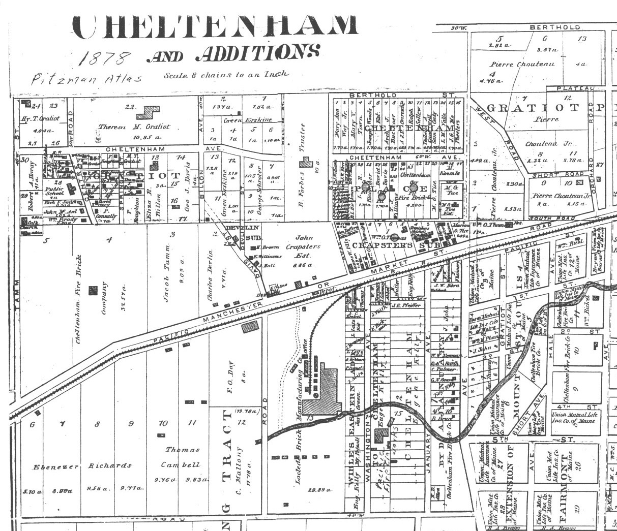
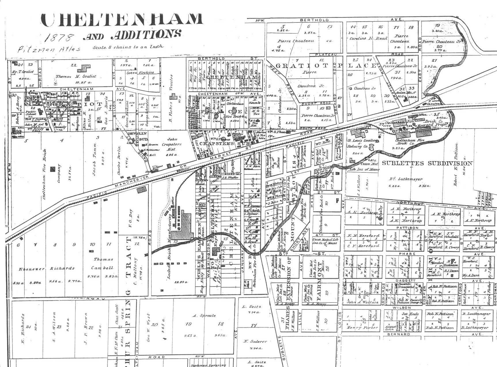
Property owners whom I can read are:
- The easy part: north of CHeltenham: Hy T. Gratiot, Theresa M. Gratiot (and note the spot of her very large house, which was (later) facing Victoria Ave., and Green Erskine.
- Along Tamm Ave. are: From South to North
- St. James Church
- Robert A. Hardy
- Between the Forbes property (eastern edge) and Billion:
- George Schroder
- Green Erskine
- From Billon to Spring: (Spring????)
- George J. Davis
- Eliza R. Billon
- P. Noughton
- Loftus
- Husson
- C. Diamond
- Between Spring and Center (Later a straighten out Graham)
- P. Connelly
- David Tracey
- Hunter Hopkins
- J.A. Coughrum
- T.M. Sweeney
- William Collins
- Hy T, Gratiot
- P. Noughton
- Between Center and the back of the Tamm properties -- From South to North
- William Brady
- John McArd
- The Public School
- M. Kennedy (two parcels)
- [Can't read]
- E.R. Billon
- McGinness and Billon
- F.L. McGinness
This section of the map runs from:
- Wade Ave. on the north (or rather what would eventually become Wade Ave.
- To Wilson Ave. on the south.
- From Tamm Ave. on the west
- To Washington Ave. on the east. I believe Washington Ave. eventually becomes today's January.
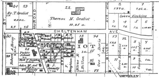
These are largely undeveloped land plots, some of them being mined by the Cheltenham Fire Brick Company in the area of Tamm and Manchester, both north and south of Manchester. Key land owners in addition to Cheltenham Fire Brick Co. are:
- Ebenezer richards
- THomas Cambell
- Jacob Tamm
- Charles Devlin
- F.O. Day
- C. Mallony.
- John Crapsters
- The homes of H. Brown, E. Williams and J. Hall are marked
- As is the tavern of E. Gittens at what is today the northeast corner of Manchester and Sulphur.
- Finally there is the large Laclede Brick Manufacturing Co. and the Railroad Depot on Manchester itself.
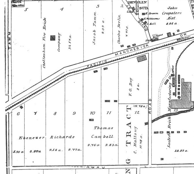
This section of the map is from:
- On the north is Plateau which became the basic direction of today's Clayton Ave
- The relevant south part is Manchester Road -- which note is called Market St. here. Henry Herbst pointed out to me that Manchester was the extension out of St. Louis of the extended Market Street and the only "highway" out of St. Louis at the time that didn't cross a river.
- On the west is "Hall St." which I am fairly sure is today's January.
- The east boundary is St. Louis Ave. which is today's Mackland Ave.
Some of the property owners in this area at this time are virtually impossible to read on this map, but what I can figure out includes:
- In the Sublette to Mackland portion the northern large piece is held by Pierre Chouteau
- While over on the western portion is another large piece of which B. Forbes is the trustee.
- In between is an intensely developed portion from Berthold to "The Alley."
Let's see what I can really read there:
- Between Cheltenham and Berthold is fairly clear: Going west from Sublette:
- J.G. McPheeters
- L.M. Valle
- Isabell A. Cantwell
- Ralph Sellew
- A.J.P. Gareschi
- Arch. J. Buckner
- Joseph Woods
- Mary V. Town
- Mary Ann Way, Jr.
- Between Cheltenham and The Alley, going west are:
- M Heemle
- THree parcels of M.G., Tice
- CHeltenham Fire Brick Co.
- T.J. Williams
- David Davis
- L.R. Blackmer
- B/L. Hickma
- Rob K. Moorey
- M.A. Mustov
- J.W. Kerr
- J. Williams
- Properties running north to south, small holdings, going from The Alley to
Cheltenham Ave are:
- J.R. Long (two plots)
- W. James
- S.E. Long
- M.L. Long
- S.E. Long
- W. James
- J.R. Long (two plots)
- Between Cheltenham and Berthold is fairly clear: Going west from Sublette:
- In the triangle east from John Crapsters Estate are:
- James W. Elly
- George Daffern
- Lewis Brown
- William O. Thomas
- Stanislaus Mittchell Fire Brick Manfacturer
- Henry Schnker
- Marion G. Tice
- William O. Thomas (residence)
Finally, I present the entire map which runs from Kingshighway to Tamm Ave. and form Old Manchester Road (Southwest Avenue today) to Berthold. I think the most interesting thing about this map is how the River Des Peres wanders down to the River Des Peres Valley. This river was not yet fully destroyed and was reputed to be a beautiful area with a great wild life area in the valley itself. This accounts for why some of St. Louis' wealthy old-money families held plots of land in the area.
| HOME | DOGTOWN |
| Bibliography | Oral history | Recorded history | Photos |
| YOUR page | External links | Walking Tour |