The Pitzman 1878 map pictures the location of the school
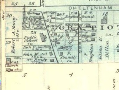 The map above is cut from the 1878 Pitzman Atlas map of Cheltenham. The detail I have
provided has Tamm Ave. on the left. (At the very bottom left corner of the map you
can see where St. James Church was, at what is today Tamm and Wade, though there was
no street where Wade is today.) At the top is "Cheltenham" which was later named
West Park. The cross-street which the school faced is Center, which is now Graham Street.
Two other identifying marks of location are:
The map above is cut from the 1878 Pitzman Atlas map of Cheltenham. The detail I have
provided has Tamm Ave. on the left. (At the very bottom left corner of the map you
can see where St. James Church was, at what is today Tamm and Wade, though there was
no street where Wade is today.) At the top is "Cheltenham" which was later named
West Park. The cross-street which the school faced is Center, which is now Graham Street.
Two other identifying marks of location are:
All these clues allow me to identify the addresses of the properties TODAY (2004) which were the former location of the school. They are:
So, the fifth to the either houses south of West Park on Graham.
| HOME | DOGTOWN |
| Bibliography | Oral history | Recorded history | Photos |
| YOUR page | External links | Walking Tour |