Pernod marked in red.
Forest Park marked in red.
Charles Gratiot is the figure we must look to for the first beginnings of settlement in the Dogtown area. All settlement and development of our neighborhood stem from the energy and effort of Charles Gratiot.
He was born in 1752 in Lausanne, Switzerland, but his ancestors had come from La Rochelle, France. He was educated in England and after arriving in St. Louis also added Spanish to his linguistic abilities. These languages aided him in succeeding in business and politics. Given this background and the French nature of early St. Louis, McCune Gill points out that his name was most likely pronounced "Sch R L Grass ioh" (Gill, 266).
Gratiot distinguished himself in the American Revolution, and in 1780 came to St. Louis at the age of 28. "He bought half a block of ground along the North side of Chestnut Street from First to Second Street with a stone house located thereon. He then built a large stone store house and office building on the lot."
Charles Gratiot's City Home at Chestnut and 2nd St.

Photo taken from Stevens, 1909.
The next year he married Victoria Chouteau, daughter of the famous Madam Marie Therese Chouteau one of the founders of St. Louis. His close association with the Chouteau family lasted his life time and aided him in both business and politics, and certain with his huge and famous land grant that so affects Dogtown.
It's rather strange for us to remember that this was Spanish land until nearly the very moment of the Louisiana Purchase. There is a tendency to think that since the founders of St. Louis were French from New Orleans, and that the Louisiana Purchase was from France, that the Louisiana Territory was French. It was and wasn't. Spain ceded Louisiana to France several years prior to the Louisiana Purchase, but France never actually took back governing power. Thus all the way to the end it was the Spanish who ran and administered Louisiana and thus early St. Louis.
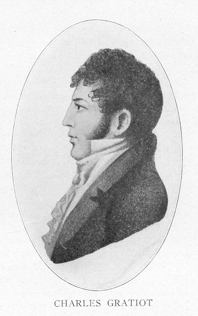
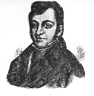
The young Charles Gratiot
Photo taken from Stevens, 1909.
Thus it was to the Spanish authorities which Charles Gratiot went in 1785 to ask for a land grant outside of St. Louis where he could commence farming and "to cultivate wheat, hemp, corn, tobacco, etc., etc." (Gill, 268.) This initial land grant was given by Don Francois de Cruzat, Lieutenant Colonel of the region and later finalized in finally confirmed by Governor Gayoso de Lemos in 1798.
After the Louisiana Purchase the United States challenged and rejected many Spanish land grants especially those made in the 1790s. However, Gratiot's position and political clout were quite secure and his grant was accepted by the United States in 1808.
To review the key movements of this grant:
- 1785 Charles Gratiot appeals for the Gratiot League Square from Don Francois de Cruzat, Lieutenant Colonel and it is granted.
- 1798 the grant is legally formalized by the Spanish Governor Gayoso de Lemos,
- 1804 the United States purchases the Louisiana Territory (including St. Louis) from the French who owned it but weren't administering it.
- 1808 the United States affirms and officially records Charles Gratiot's huge land grant.
Thanks to McCune Gill there are English translations of all the essential documents of the grant. They are here for your pleasure. (Gill, pp. 268-270)
It is mind-boggling to sit down and think today of just what Charles Gratiot was given. He received nearly a full league square. A league is just about 3 miles.
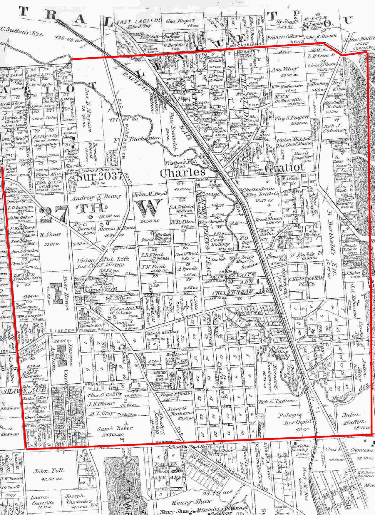
Thus a perfect league square would be a piece of land where each of the four sides was three miles. However in the final grant his "league square" was a bit short on the north-south line and a full league on the east-west line, so it's a bit of a rectangle rather than a square. The rough borders in today's St. Louis are:- East boundary:
Kingshighway.- West boundary:
McCausland.- Northern boundary:
About the middle of Forest Park- Southern boundary:
Pernod Ave.
=============================================================================
The McCausland Side. The red line is along McCausland. The actual end of Gratiot's land is just a bit west of McCausland, as is the current border of the City of St. Louis by about 1 1/2 blocks.
Pernod marked in red. |
|
Forest Park marked in red. |
The Kindshighway Side. The red line is along Kingshighway Blvd.
Map is taken from 1878 Pitzman map of St. Louis
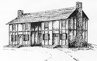
Charles Gratiot had already built a house on the land in 1790 and begun his work of cultivating and developing it. This was not his main home. That remained his city home on Chestnut. This was his "country" home and he even had a few neighbors, having sold off a few parcels of land to other "gentlemen farmers." The 1790 home seems to have been improved upon a bit and looks a bit different in 1810.
The 1790 home is on the left; the 1810 on the right
 |
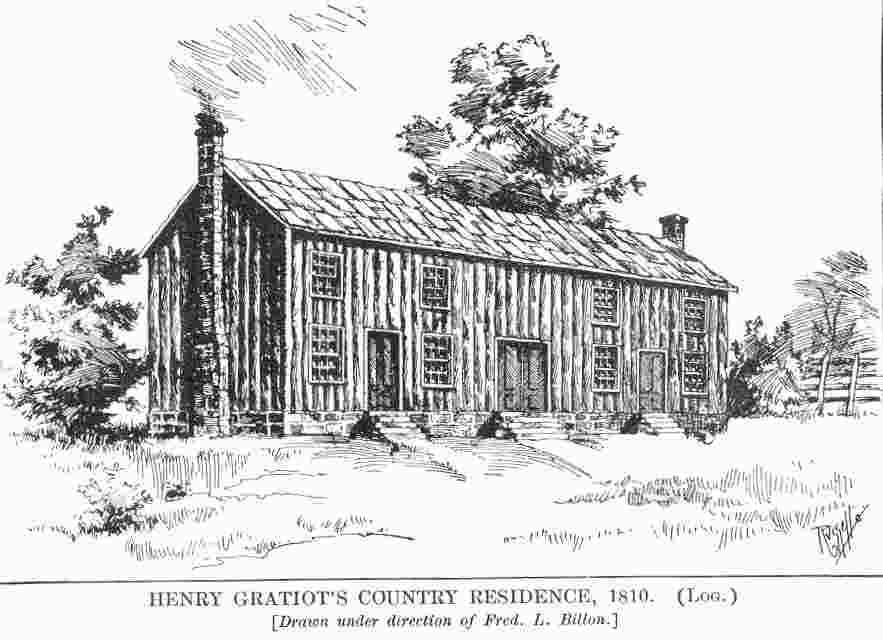 |
Photo of 1790 house taken from Stevens, 1909.
Photo of 1810 house taken from Billon, 1888.
Frederick Billon describes the Gratiot country home as: "A weather board log house 1 1-2 stories high, 50 feet long, by 16 deep, on a stone foundation about 4 feet high, with a stone chimney at each end. Three doors on the east front, one to each room, with a shed over the steps to each, in place of the gallery which originally extended along the whole front of 50 feet; the rear gallery still remains, in a dilapidated condition.
"It stands on high ground overlooking the country in each direction, about three-eighths of a mile west of the King's Highway, which is the east line of the "Gratiot League Square," and 150 yards north of Pattison Avenue which leads to it.
"A deep well of water stands about 50 yards north-east of the house. A part of the stone foundations of Gratiot's old mill, are still to be seen, (1881) a short distance north of the house, on the slope of the hill which descends to the river Des Peres, and the ruins of the old stone spring-house, in a hollow about 200 yards east, as also a number of old dead apple-trees in the orchard." (Billon, p. 173.)
In the 1875 Pictorial Map of St. Louis, Camille Dry has the Gratiot house. It would be described as being just to the east of Mackland Ave. It is just below Pattison Ave., where Mackland begins its steep descent from The Hill down toward the railroad tracks. (Dry, plate 98)
Below are two photos of aerial drawings of St. Louis in 1875. First there is most of the River des Peres valley as it was at that time. I have marked the spot of Charles Gratiot's house in red.
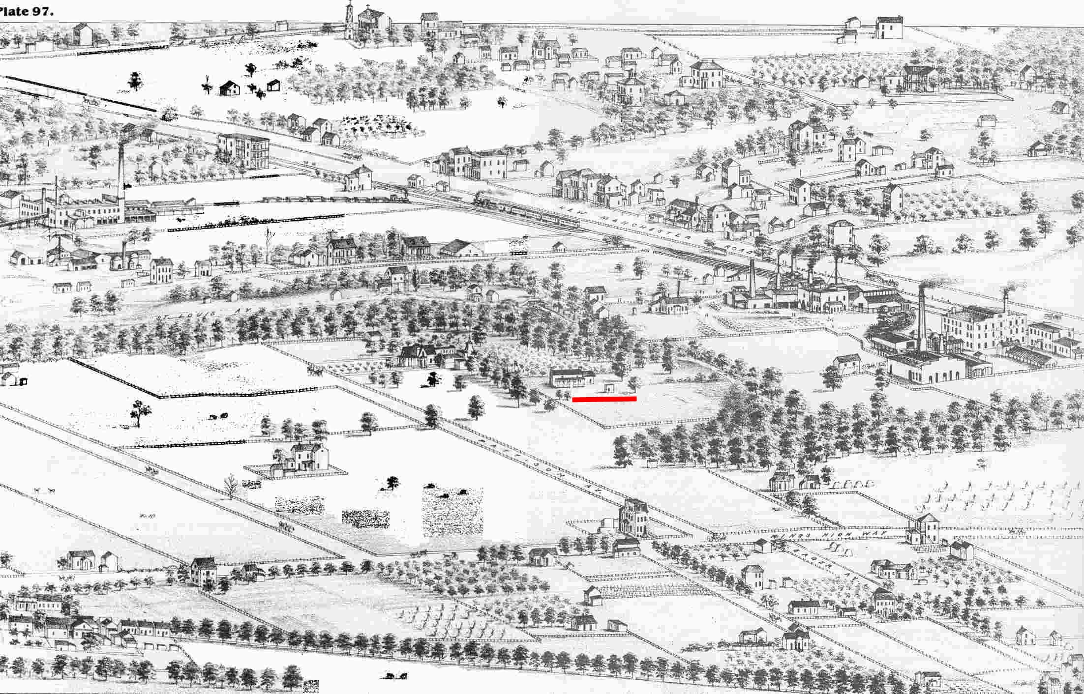
Map taken from Dry, plate 98
A few comments on the photo above:
This second close up of the map shows it just as Billon had described it, just below Pattison and just east of Mackland.
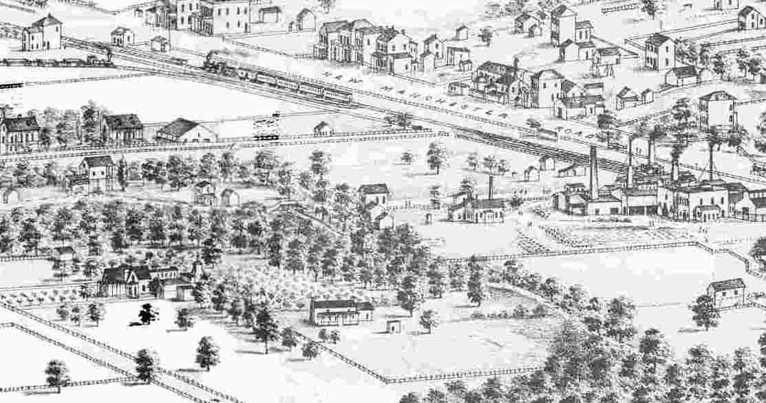
Map taken from Dry, plate 98
Some comments on the photo above:
The central piece of Gratiot's land and where he built his home, was on the shelf of a slight hill overlooking the beautiful River des Peres. Father P.J. O'Connor, quoting a bulletin from the Missouri Botanical Garden, describes the marvel that this land held before mining and brick making changed it all.
Father O'Connor says: "In the old Gratiot League Square there was a region almost up to 1860 idyllic in its native aspect.** This was the little valley of the River des Peres stretching between the present Forest Park southwestwardly to Knox Avenue. Its slopes had originally been covered with the tree growth common to Missouri stream courses. A group of lordly oaks shaded seigniorialy a clump of papaws. Here and there leaned over the des Peres the dapple-bark of sycamore. Again, and solitary, stood a gigantic cottonwood. There were thickets of hazel, stretches of wild apple, and on the uplands one struggled through the briars of wild blackberry. (Bulletin -- Shaw's Garden)" (O'Connor, p. 8.)
** [Corbett notes: With all due respect to Father O'Connor and the author of the Shaw's Garden Bulletin, 1860 is a bit generous. Two serious brick factories were operating by 1855 and it was just a few months of that and the River des Peres was not only no longer a paradise, it was a large sewer.]
Charles Gratiot was charged with developing the land he was given. He did have his farm and cultivated it, built a small mill and distillery. He sold some plots of land (and purchased others outside his "league square.")

Photo taken from Stevens, 1909
Charles Gratiot in his fully established senior years
After the American purchase he became a judge and very prominent figure in St. Louis business and politics. Charles died in 1817 at the age of 65, the land was divided into 12 east-west narrow strips. Each strip was only about 1,000 feet wide, but three miles long. In some of the strips land had already been sold to other people.
There were just three of the strips of the "old" square which impact the neighborhood of Dogtown. These were inherited by: (City Hall document, 1819)
1927.2ft. wide n/s, the full 3 miles e/w strip on a line with Valley Rd. (Dale) on the north and Glades and Phare (Shaw) on the south.
1131.9ft. wide n/s, the full 3 miles e/w strip on a line with Wise on the north, and Valley Rd (Dale) on the south.
1131.9ft. wide n/s, the full 3 miles e/w strip on a line the south edge of Forest Park Oakland) on the north, and Wise on the south.
(Louis Schmidt's notations from City Hall documents.)
The map below is marked into three strips to roughly separate the space of Gratiot inheritance:
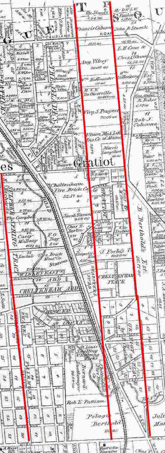
Map is taken from 1878 Pitzman map of St. Louis
Henry had the real plum. He got the beautiful River des Peres section and his father's house. Some of the sources say he built a house, but the descriptions that have survived indicate that Charles' 1790 house, remodeled some in 1810, is also Henry's house. According to Billon's account it would have been the young Henry who remodeled the family country home in 1810, not his father. This would make sense. His father was approaching 60, busy with politics and business in the city and the trip to the country would not have been a convenient one for him. Yet having Henry live there and oversee the cultivation and develop of the land would continue to meet the obligation of the grant.Billon tells us that Henry "�when a young man built a house and improved a farm on his father's league square on the King's Highway, five miles from the Town, where be lived for some years, previous to and after his marriage. " (Billon, p. 173.)After his marriage in 1813 he lived on the farm and some of his children were born there. However, "� [i]n 1825, with his brother John P. B. Gratiot, he went with the rush to the "Fevre River" lead mines at Galena, Ill. and established themselves at the place named after them "Gratiot's Grove" (Billion, p. 173.)
Henry Gratiot -- Lived in this area 1810 - 1831
Henry never returned to St. Louis to live and shortly after sold the land to Bill Sublette, but more about this later.
Paul Benjamin Gratiot became a genuine resident farmer of the area and his family remained into the fourth generation. He went off with his two brothers to Gratiot's Grove, but tired of that life. He returned to St. Louis in 1832 and with his wife and children moved onto his property. He built a farm house, which was built onto and around, being often reshaped in the process. The eventual home was at 6135 Victoria. The home used both local timber and bricks made on the premises by slaves of the Gratiot family. Paul Benjamin died in 1855. However, the large family home accommodated quite a few people and in the 1900 census there are no fewer than 4 of his own children living there. They were, of course fairly elderly. Adolph who was married and had a family of his own seems to have been regarded as the head of the family. His unmarried siblings, Benjamin, Henry and Theresa also lived there. Adolph's children took over the house and lived there into the next generation. The fourth and final generation of Gratiot descendants continued in the home until it was finally demolished in 1959 after 127 years of service. (Barns, 1989).Another of Adolph's brothers, Paul Benjamin's son, Charles, was a physician and lived at the corner of West Park and Hampton.
The Gratiot family's contribution is primarily Charles' role of opening the area to settlement. After his death in 1817 only Henry (briefly) and the Paul Benjamin family every lived in the area.
Henry sold his plum of a plot in 1831 and the next owners introduced massive changes, exploiting the rich fire clay of the region, and in the process created the economy which allowed most of our 19th century Dogtown residents to be able to come here. But that's a later story to be told.
Paul Benjamin Gratiot's family were not very active in the neighborhood. They lived on the land, farming in the earliest years and as residents at 6125 Victoria in later generations. The land was gradually sold off into small lots which became the very heart of residential Dogtown:
- Hampton to Childress
- Clayton to Lloyd
| HOME | DOGTOWN |
| Bibliography | Oral history | Recorded history | Photos |
| YOUR page | External links | Walking Tour |