MAP OF DOGTOWN MINES AND BRICK FACTORIES IN 1905
From: FOREST PARK
By: Caroline Louighlin and Catherine Anderson
St. Louis: The Junior League of St. Louis, 1986
Page 60
This map includes Forest Park, and then the Dogtown/Cheltenham area. There are
very small numbers on the map and often they repeat. For example # 1 is the Evens and
Howard Brick Company mines and since they were all over the place, the # 1 is in several
places on the map.
The streets are not named. However, you can read the word "Cheltenham" on the
lower half the map, just left of center. The "l" of the word "Cheltenham" is the
corner of West Park and Tamm. (West Park was then called Cheltenham). From there
you can figure out most of the streets. See legend below the photo.
The THICK BLACK LINE running through the map is The River Des Peres as it passes
through Forest Park and Dogtown.
In addition to the Dogtown related material, there are also other landmarks and
locations of Streetcar lines in this area in 1901. See below
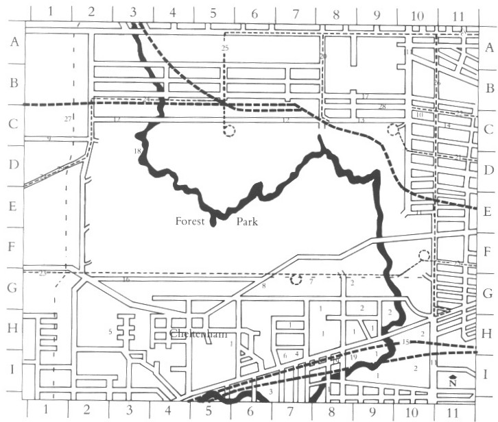
Location of Brick and Fire Clay Companies, 1905
- 1. Evens and Howard Brick Co., H-5 to I-9
- 2. Hydraulic Press Brick Co., G-9 to I-10
- 3. Laclede Fire Brick Company, I-6 and 7
- 4. Mitchell Clay Co., I-7
- 5. Missouri Fire Brick Co., H-2 and 3
- 6. Winkle Terra Cotta Co., I-7
- 7. Forest Park Highlands, G-7 and 8
- 8. Forest Park University, G-6
Other marked landmarks
- 9. Forsyth Boulevard (later Forsyth Avenue), C-1 and 2
- 10. Kauffman (later Bixby) house, C-10
- 11. King's Highway (later Kingshighway Boulevard), A-10 to I-10
- 12. Lindell Avenue (Skinker Road to Union Boulevard, private street until 1909), C-2 to C-8
- 13. Lindell Avenue (Union Boulevard to Kings Highway, formerly Park Road, then Forest Park Terrace), C-8 to C-10 14. Lindell Boulevard (east of Kings Highway), C-10 and 11
- 15. Missouri Pacific Railroad, I-5 to H-11
- 16. Oakland Avenue, G-2 to G-6
- Park Road, see 13, C-8 to C-10
- 17. Portland Place, B-8 to B-10
- 18. River des Press, A-3 to I-5
- 19. St. Louis Smelting and Refining Works,
Streetcar Lines, 1901
- 20. St. Louis and Suburban Railway Company, Forest Park Division, A-8 to C-8
- 21. United Railways Company, Central Division (formerly Forest Park, Laclede Av. and Fourth Street Railroad Company) Laclede Avenue Line, C-9 to D-11
- 22. United Railway Company, Central Division (formerly Missouri Railroad Company, cable), Olive Street LIne, C-10 and 11
- 23. United Railways Company, Lindell Division (formerly Lindell Railway Company), Chouteau Avenue line, G-1 to F-11
- 24. United Railways Company, Lindell Division (formerly Lindell Railway Company), Clayton Line, B-5 to E-1.
- 25. United Railways Company, Lindell Division (formerly Lindell Railway Company), Delmar Avenue Line, A-11 to C-5.
- 26. United Railways Company, Lindell Division (formerly Lindell Railway Company), Euclid Avenue LIne, A-10 to H-11.
- 27. Washington University site, C-1 and 2
- 28. Westmoreland Place, C-8 to C-10
- 29. Wydown Boulevard, D-2 to E-1
Bob Corbett
corbetre@webster.edu